
Make a donation
Gear up for your next adventure:
As an Amazon Associate, this site earns from qualifying purchases at no extra cost to you.
Puy de Crouël topographic map
Click on the map to display elevation.
Make a donation
Gear up for your next adventure:
As an Amazon Associate, this site earns from qualifying purchases at no extra cost to you.
Puy de Crouël
Ce sommet se situe dans le périmètre urbain de Clermont-Ferrand. Il est bordé à l'est par l'autoroute A75. Il culmine à 427 mètres d'altitude.
Make a donation
Gear up for your next adventure:
As an Amazon Associate, this site earns from qualifying purchases at no extra cost to you.
About this map
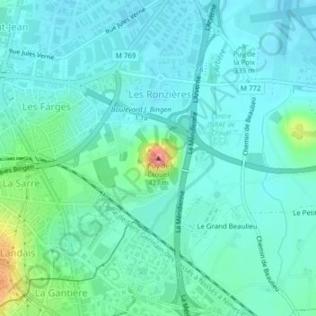
Name: Puy de Crouël topographic map, elevation, terrain.
Average elevation: 345 m
Minimum elevation: 329 m
Maximum elevation: 414 m
Make a donation
Gear up for your next adventure:
As an Amazon Associate, this site earns from qualifying purchases at no extra cost to you.
Other topographic maps
Click on a map to view its topography, its elevation and its terrain.
Parc de Montjuzet
France > Auvergne-Rhône-Alpes > Puy-de-Dôme > Clermont-Ferrand
Average elevation: 437 m