Geolocate

Takalar topographic map

Click on the map to display elevation.

About this map

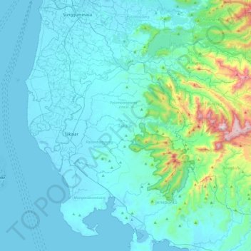
Name: Takalar topographic map, elevation, terrain.

Location: Takalar, Lantang, South Sulawesi, Sulawesi, Indonesia (-5.60741 119.19008 -5.20591 119.64610)

Average elevation: 124 m

Minimum elevation: -4 m

Maximum elevation: 1,124 m

Gear up for your next adventure:

💧Reusable Water Bottle - Durable water bottles for hydration on trails
🥾Waterproof Trail Shoes - Shoes designed to handle wet terrain
🚲MTB Frame Bag - Carry tools and maps directly on your bicycle frame
🕯️Camping Lantern - Illuminates your entire campsite with high-efficiency LEDs
🌬️Windproof Camp Stove - Efficient cooking even on exposed mountain peaks

As an Amazon Associate, this site earns from qualifying purchases at no extra cost to you.