
Make a donation
Gear up for your next adventure:
As an Amazon Associate, this site earns from qualifying purchases at no extra cost to you.
Farnroda topographic map
Click on the map to display elevation.
Make a donation
Gear up for your next adventure:
As an Amazon Associate, this site earns from qualifying purchases at no extra cost to you.
Farnroda
Farnroda ist ein Ortsteil der Gemeinde Wutha-Farnroda im Wartburgkreis in Westthüringen. Der Ortsteil mit etwa 1485 Einwohnern liegt am Nordrand des Thüringer Waldes, etwa 10 Kilometer Luftlinie südöstlich von Eisenach auf einer Höhe von 260 bis 300 Metern, die Gesamtfläche der Gemarkung beträgt 6,21 km².
Make a donation
Gear up for your next adventure:
As an Amazon Associate, this site earns from qualifying purchases at no extra cost to you.
About this map
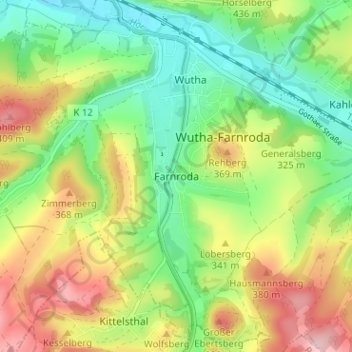
Name: Farnroda topographic map, elevation, terrain.
Average elevation: 310 m
Minimum elevation: 228 m
Maximum elevation: 430 m
Make a donation
Gear up for your next adventure:
As an Amazon Associate, this site earns from qualifying purchases at no extra cost to you.
Other topographic maps
Click on a map to view its topography, its elevation and its terrain.