Geolocate

Santa María topographic map

Click on the map to display elevation.

About this map

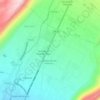
Name: Santa María topographic map, elevation, terrain.

Location: Santa María, San Jose, Calana, Tacna, Perú (-17.95301 -70.19169 -17.91301 -70.15169)

Average elevation: 971 m

Minimum elevation: 850 m

Maximum elevation: 1,301 m

Gear up for your next adventure:

🪑Insulated Seat Pad - Protect your seat from cold rocks and wet logs
🥾Hiking Gaiters - Protect legs and shoes from mud, snow, and debris
🧰Survival Kit - Essential gear for emergencies in the wilderness
🧢Beanie Hat - Keep your head warm in cold weather
Tent Footprint - Protect tent floor and increase durability

As an Amazon Associate, this site earns from qualifying purchases at no extra cost to you.