
Make a donation
Gear up for your next adventure:
As an Amazon Associate, this site earns from qualifying purchases at no extra cost to you.
Cebollar topographic map
Click on the map to display elevation.
Make a donation
Gear up for your next adventure:
As an Amazon Associate, this site earns from qualifying purchases at no extra cost to you.
About this map
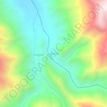
Name: Cebollar topographic map, elevation, terrain.
Average elevation: 3,107 m
Minimum elevation: 2,703 m
Maximum elevation: 3,871 m
Make a donation
Gear up for your next adventure:
As an Amazon Associate, this site earns from qualifying purchases at no extra cost to you.
Other topographic maps
Click on a map to view its topography, its elevation and its terrain.
Sapahaqui
Bolivia > La Paz > Provincia Loayza > Municipio Sapahaqui
Sapahaqui es una localidad y municipio de Bolivia, en la Provincia de José Ramón Loayza del Departamento de La Paz. Cuenta con una población de 12.484 habitantes (2012). Se sitúa a una altitud de 3.134 m s. n. m. También es una área verde rico en flora y fauna
Average elevation: 3,273 m