
Make a donation
Gear up for your next adventure:
As an Amazon Associate, this site earns from qualifying purchases at no extra cost to you.
Le Haougara topographic map
Click on the map to display elevation.
Make a donation
Gear up for your next adventure:
As an Amazon Associate, this site earns from qualifying purchases at no extra cost to you.
About this map
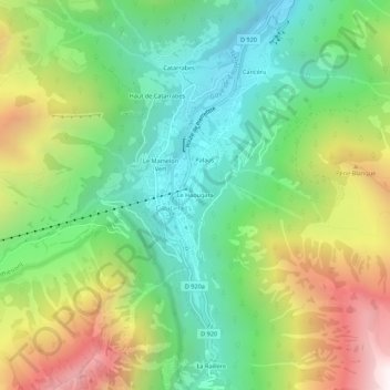
Name: Le Haougara topographic map, elevation, terrain.
Average elevation: 1,405 m
Minimum elevation: 826 m
Maximum elevation: 2,392 m
Make a donation
Gear up for your next adventure:
As an Amazon Associate, this site earns from qualifying purchases at no extra cost to you.
Other topographic maps
Click on a map to view its topography, its elevation and its terrain.
Glacier des Oulettes de Gaube
France > Occitanie > Hautes-Pyrénées > Cauterets
Average elevation: 2,688 m
Glacier du Petit Vignemale
France > Occitanie > Hautes-Pyrénées > Cauterets
Average elevation: 2,699 m
Lac de Gaube
France > Occitanie > Hautes-Pyrénées > Cauterets
Le lac se situe à une altitude de 1 725 mètres, il est d'une forme ovoïde s'étirant selon un axe nord-sud comme la vallée de Gaube dans laquelle il se trouve. C'est une petite vallée encaissée démarrant au pied du Vignemale (3 298 m) et finissant au pont d'Espagne. Le lac se trouve dans son dernier…
Average elevation: 2,079 m
Make a donation
Gear up for your next adventure:
As an Amazon Associate, this site earns from qualifying purchases at no extra cost to you.
Lac de Gaube
France > Occitanie > Hautes-Pyrénées > Cauterets
Le lac se situe à une altitude de 1 725 mètres, il est d'une forme ovoïde s'étirant selon un axe nord-sud comme la vallée de Gaube dans laquelle il se trouve. C'est une petite vallée encaissée démarrant au pied du Vignemale (3 298 m) et finissant au pont d'Espagne. Le lac se trouve dans son dernier…
Average elevation: 2,079 m