Geolocate

Guaynabo topographic map

Click on the map to display elevation.

About this map
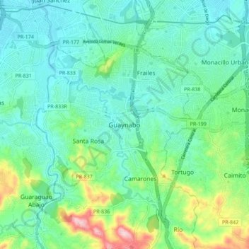
Name: Guaynabo topographic map, elevation, terrain.

Location: Guaynabo, Puerto Rico, 00969, United States (18.31787 -66.15201 18.39787 -66.07201)

Average elevation: 70 m

Minimum elevation: 5 m

Maximum elevation: 283 m

Gear up for your next adventure:

⛺Lightweight Camping Tent - Portable shelter optimized for Canadian backcountry camping
💡Compact LED Flashlight - Powerful and portable flashlight for outdoor use
🧢Sun Hat - Wide-brim hat for sun protection
📷Outdoor Action Camera - Capture high-elevation views and rugged adventures
🧴Insect Repellent - Protect yourself from bugs during outdoor adventures

As an Amazon Associate, this site earns from qualifying purchases at no extra cost to you.