
Denpasar topographic map
Interactive map
Click on the map to display elevation.
About this map
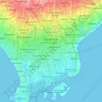
Name: Denpasar topographic map, elevation, terrain.
Location: Denpasar, Bali, Indonésie (-8.75254 115.17319 -8.59084 115.27409)
Average elevation: 23 m
Minimum elevation: -2 m
Maximum elevation: 101 m
Other topographic maps
Click on a map to view its topography, its elevation and its terrain.
Dauh Puri Kangin
Indonésie > Bali > Denpasar > Dauh Puri Kangin
Dauh Puri Kangin, Denpasar Barat, Denpasar, Bali, 80232, Indonésie
Average elevation: 26 m