Geolocate

Sector 29 topographic map

Click on the map to display elevation.

About this map
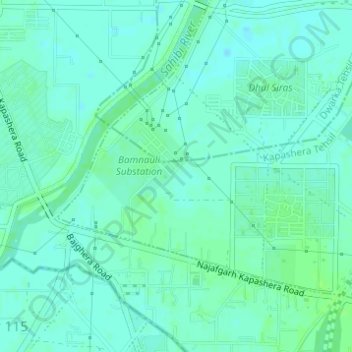
Name: Sector 29 topographic map, elevation, terrain.

Location: Sector 29, Delhi, South West Delhi, Delhi, India (28.53936 77.01175 28.55514 77.03021)

Average elevation: 213 m

Minimum elevation: 209 m

Maximum elevation: 219 m

Other topographic maps

Click on a map to view its topography, its elevation and its terrain.
Yamuna Biodiversity Park

India > Delhi > Delhi

Average elevation: 209 m

Aastha Kunj

India > Delhi > Delhi

Average elevation: 223 m

Ghitorni

India > Delhi > Delhi

Average elevation: 268 m

Gear up for your next adventure:

🥤Collapsible Travel Cup - Saves space and weight in your mess kit
💡LED Headlamp - Hands-free illumination for night hiking and camping
🔭Compact Monocular - One-handed bird watching and trail spotting
🧥Softshell Jacket - Windproof and breathable jacket for hiking
⛺Bushcraft Tarp - Versatile emergency shelter or gear protection

As an Amazon Associate, this site earns from qualifying purchases at no extra cost to you.