
Make a donation
Gear up for your next adventure:
As an Amazon Associate, this site earns from qualifying purchases at no extra cost to you.
Waghäusel topographic map
Click on the map to display elevation.
Make a donation
Gear up for your next adventure:
As an Amazon Associate, this site earns from qualifying purchases at no extra cost to you.
Waghäusel
Der Gemeinderat hat normalerweise 26 ehrenamtliche Mitglieder, die für fünf Jahre gewählt werden. Die Gemeinderäte führen die Bezeichnung Stadtrat. Die Zahl der Gemeinderäte kann sich durch Ausgleichssitze erhöhen (gesamt 2019: 28 Sitze; 2014: 29). Hinzu kommt der Bürgermeister als stimmberechtigter Gemeinderatsvorsitzender.
Make a donation
Gear up for your next adventure:
As an Amazon Associate, this site earns from qualifying purchases at no extra cost to you.
About this map
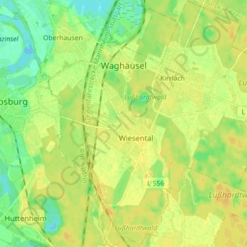
Name: Waghäusel topographic map, elevation, terrain.
Average elevation: 106 m
Minimum elevation: 93 m
Maximum elevation: 115 m
Make a donation
Gear up for your next adventure:
As an Amazon Associate, this site earns from qualifying purchases at no extra cost to you.
Other topographic maps
Click on a map to view its topography, its elevation and its terrain.
Östringen
Deutschland > Baden-Württemberg > Landkreis Karlsruhe > Östringen > Östringen
Average elevation: 177 m
Justizvollzugsanstalt Bruchsal - Außenstelle Kislau
Deutschland > Baden-Württemberg > Landkreis Karlsruhe > Bad Schönborn
Average elevation: 116 m
Make a donation
Gear up for your next adventure:
As an Amazon Associate, this site earns from qualifying purchases at no extra cost to you.