Geolocate

Sonora topographic map

Click on the map to display elevation.

About this map

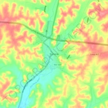
Name: Sonora topographic map, elevation, terrain.

Location: Sonora, Sutton County, Texas, 76950, United States (30.52673 -100.68286 30.60673 -100.60286)

Average elevation: 675 m

Minimum elevation: 636 m

Maximum elevation: 712 m

Gear up for your next adventure:

🥾Trekking Boots - Durable boots for long-distance trekking
🧊Insulated Water Bottle - Keeps drinks cold in summer and prevents freezing in winter
Backpacking Tent - Lightweight tent for long-distance hiking trips
👖Convertible Hiking Pants - Zip-off legs to adapt to changing weather conditions
🧢Outdoor Cap - Protective cap for sun and rain during hikes

As an Amazon Associate, this site earns from qualifying purchases at no extra cost to you.