Geolocate

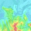
Sulina topographic map

Click on the map to display elevation.

About this map
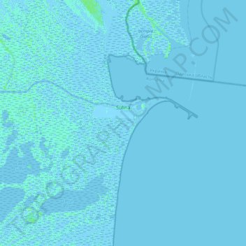
Name: Sulina topographic map, elevation, terrain.

Location: Sulina, Tulcea, 825400, Romania (45.03968 29.39411 45.23842 29.76841)

Average elevation: 0 m

Minimum elevation: -5 m

Maximum elevation: 6 m

Other topographic maps

Click on a map to view its topography, its elevation and its terrain.

Canalul Lipovenilor

Romania > Tulcea

Average elevation: 12 m

Tulcea

Romania > Tulcea

Average elevation: 25 m

Sălcioara

Romania > Tulcea

Average elevation: 16 m

Islazu

Romania > Tulcea > Hamcearca

Average elevation: 184 m

Vasile Alecsandri

Romania > Tulcea

Average elevation: 258 m

Dealul cu Drum

Romania > Tulcea > Greci

Average elevation: 168 m

Pătlăgeanca

Romania > Tulcea

Average elevation: 4 m

Caraorman

Romania > Tulcea

Average elevation: 1 m

Pietrosu Mic

Romania > Tulcea > Luncavița

Average elevation: 308 m

La Tene

Romania > Tulcea > Cârjelari

Average elevation: 217 m

Lăstuni

Romania > Tulcea

Average elevation: 36 m

Cataloi

Romania > Tulcea

Average elevation: 58 m

Gear up for your next adventure:

🧼Biodegradable Camp Soap - Environmentally friendly cleaning for gear and body
💧Hydration Pack - Hands-free hydration system for long hikes
🥾Light Hiking Boots - Lightweight and comfortable boots for day hikes
⛺Family Camping Tent - Spacious tent suitable for family camping trips
💧Filtered Water Bottle - Safe drinking water on the go

As an Amazon Associate, this site earns from qualifying purchases at no extra cost to you.