
Make a donation
Gear up for your next adventure:
As an Amazon Associate, this site earns from qualifying purchases at no extra cost to you.
Lautenthal topographic map
Click on the map to display elevation.
Make a donation
Gear up for your next adventure:
As an Amazon Associate, this site earns from qualifying purchases at no extra cost to you.
Lautenthal
Lautenthal liegt im Innerstetal zwischen dem Clausthal-Zellerfelder Ortsteil Wildemann und Langelsheim im nordwestlichen Oberharz. Der Ort befindet sich auf einer Höhe von ungefähr 300 m ü. NN in einem Talkessel, wobei die umliegenden Berge Höhen bis 620 m ü. NN erreichen. Die beiden Flüsse Innerste und Laute durchfließen die Bergstadt. In Richtung Langelsheim wird die Innerste zur Innerstetalsperre angestaut.
Make a donation
Gear up for your next adventure:
As an Amazon Associate, this site earns from qualifying purchases at no extra cost to you.
About this map
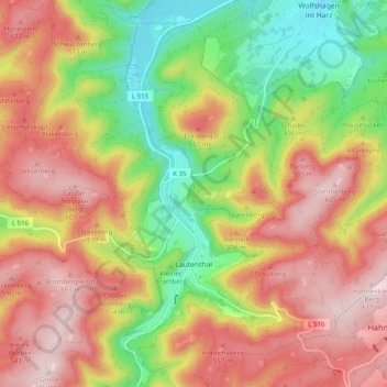
Name: Lautenthal topographic map, elevation, terrain.
Average elevation: 441 m
Minimum elevation: 246 m
Maximum elevation: 617 m
Make a donation
Gear up for your next adventure:
As an Amazon Associate, this site earns from qualifying purchases at no extra cost to you.
Other topographic maps
Click on a map to view its topography, its elevation and its terrain.
Ostlutter
Deutschland > Niedersachsen > Landkreis Goslar > Langelsheim
Der Ort liegt am südwestlichen Ende des bewaldeten Höhenzugs Wahrenberg, einem Teil des Innersteberglands.
Average elevation: 210 m