Geolocate

Laz topographic map

Click on the map to display elevation.

About this map

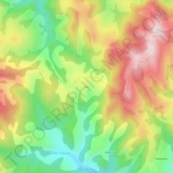
Name: Laz topographic map, elevation, terrain.

Location: Laz, Vințu de Jos, Alba, 517884, Romania (46.03226 23.39794 46.07226 23.43794)

Average elevation: 643 m

Minimum elevation: 391 m

Maximum elevation: 916 m

Gear up for your next adventure:

🧶550 Survival Paracord - Versatile utility cord for emergency repairs and rigging
🧥Packable Rain Jacket - Breathable waterproof layer for unpredictable weather
🕶️Polarized Sunglasses - Reduces glare from snow and water at high elevations
🛶Kayak Dry Bag - Waterproof storage for kayaking adventures
💡LED Headlamp - Hands-free illumination for night hiking and camping

As an Amazon Associate, this site earns from qualifying purchases at no extra cost to you.