Geolocate

Napa topographic map

Click on the map to display elevation.

About this map

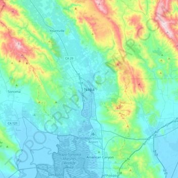
Name: Napa topographic map, elevation, terrain.

Location: Napa, Napa County, California, 94559, United States (38.13714 -122.44553 38.45714 -122.12553)

Average elevation: 166 m

Minimum elevation: -5 m

Maximum elevation: 850 m

Gear up for your next adventure:

🥾Trail Hiking Socks - Comfortable socks to prevent blisters and fatigue
🥾Lightweight Hiking Boots - Boots for comfort and mobility on long hikes
🔭Compact Monocular - One-handed bird watching and trail spotting
🥾Waterproof Hiking Boots - Essential footwear for rugged terrain and wet Canadian trails
🛰️Satellite Messenger - Emergency communication for areas with no cell service

As an Amazon Associate, this site earns from qualifying purchases at no extra cost to you.