
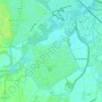
Weckhoven topographic map
Interactive map
Click on the map to display elevation.
About this map
Name: Weckhoven topographic map, elevation, terrain.
Average elevation: 42 m
Minimum elevation: 37 m
Maximum elevation: 49 m
Other topographic maps
Click on a map to view its topography, its elevation and its terrain.
Allerheiligen
Deutschland > Nordrhein-Westfalen > Rhein-Kreis Neuss > Neuss
Allerheiligen, Neuss, Rhein-Kreis Neuss, Nordrhein-Westfalen, 41470, Deutschland
Average elevation: 42 m
Speck
Deutschland > Nordrhein-Westfalen > Rhein-Kreis Neuss > Neuss
Speck, Neuss, Rhein-Kreis Neuss, Nordrhein-Westfalen, 41472, Deutschland
Average elevation: 48 m
Grefrath
Deutschland > Nordrhein-Westfalen > Rhein-Kreis Neuss > Neuss > Grefrath
Grefrath, Neuss, Rhein-Kreis Neuss, Nordrhein-Westfalen, Deutschland
Average elevation: 53 m
Minkel
Deutschland > Nordrhein-Westfalen > Rhein-Kreis Neuss > Neuss > Helpenstein > Minkel
Minkel, Holzheim, Helpenstein, Neuss, Rhein-Kreis Neuss, Nordrhein-Westfalen, 41472, Deutschland
Average elevation: 50 m