Geolocate

Rhede (Ems) topographic map

Click on the map to display elevation.

About this map
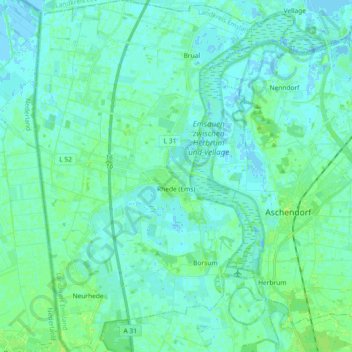
Name: Rhede (Ems) topographic map, elevation, terrain.

Location: Rhede (Ems), Landkreis Emsland, Nedersaksen, 26899, Duitsland (53.00692 7.19922 53.11727 7.31656)

Average elevation: 3 m

Minimum elevation: -4 m

Maximum elevation: 10 m

Other topographic maps

Click on a map to view its topography, its elevation and its terrain.

Gleesen

Duitsland > Nedersaksen > Landkreis Emsland

Average elevation: 29 m

Neusustrum

Duitsland > Nedersaksen > Landkreis Emsland

Average elevation: 11 m

Hesselte

Duitsland > Nedersaksen > Landkreis Emsland > Emsbüren

Average elevation: 31 m

Sprakel

Duitsland > Nedersaksen > Landkreis Emsland > Stavern

Average elevation: 39 m

Sand

Duitsland > Nedersaksen > Landkreis Emsland > Oberlangen

Average elevation: 10 m

Haar

Duitsland > Nedersaksen > Landkreis Emsland > Haren (Ems)

Average elevation: 15 m

Gear up for your next adventure:

🛌Down Sleeping Bag - Superior warmth-to-weight ratio for cold nights
💡LED Headlamp - Hands-free illumination for night hiking and camping
🥾Trekking Boots - Durable boots for long-distance trekking
🧥Softshell Jacket - Windproof and breathable jacket for hiking
🧦Thermal Socks - Warm socks for winter hiking or camping

As an Amazon Associate, this site earns from qualifying purchases at no extra cost to you.