Geolocate

Carlton topographic map

Click on the map to display elevation.

About this map

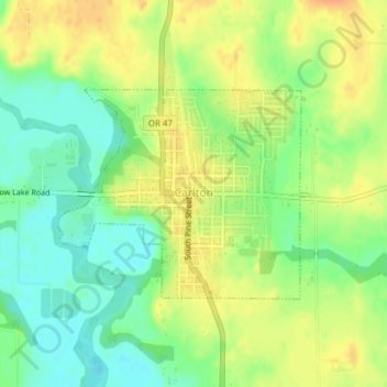
Name: Carlton topographic map, elevation, terrain.

Location: Carlton, Yamhill County, Oregon, United States (45.28682 -123.19006 45.30143 -123.16476)

Average elevation: 51 m

Minimum elevation: 32 m

Maximum elevation: 68 m

Other topographic maps

Click on a map to view its topography, its elevation and its terrain.

Amity Hills

United States > Oregon > Yamhill County > Amity

Average elevation: 108 m

Gear up for your next adventure:

🧤Rechargeable Heated Gloves - Extreme warmth for Canadian winter expeditions
👟Sport Hiking Sandals - Breathable footwear for water crossings and camp rest
🔭Compact Binoculars - Lightweight optics for scouting trails and wildlife
Camping Tent - Weather-resistant tents suitable for 2 to 6 people
🥾Waterproof Trail Shoes - Shoes designed to handle wet terrain

As an Amazon Associate, this site earns from qualifying purchases at no extra cost to you.