Geolocate

Katigora topographic map

Click on the map to display elevation.

About this map

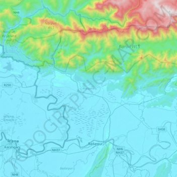
Name: Katigora topographic map, elevation, terrain.

Location: Katigora, Cachar, Assam, India (24.82725 92.41851 25.14293 92.82311)

Average elevation: 237 m

Minimum elevation: 8 m

Maximum elevation: 1,697 m

Gear up for your next adventure:

👟Sport Hiking Sandals - Breathable footwear for water crossings and camp rest
🧭GPS Handheld Device - Reliable GPS navigation for outdoor adventures
Lightweight Backpacking Tent - Compact tent for efficient hiking trips
🧥Packable Rain Jacket - Breathable waterproof layer for unpredictable weather
🧴Outdoor Sunscreen - High SPF protection for high-altitude UV exposure

As an Amazon Associate, this site earns from qualifying purchases at no extra cost to you.