
Make a donation
Gear up for your next adventure:
As an Amazon Associate, this site earns from qualifying purchases at no extra cost to you.
Culdesac topographic map
Click on the map to display elevation.
Make a donation
Gear up for your next adventure:
As an Amazon Associate, this site earns from qualifying purchases at no extra cost to you.
Culdesac
Culdesac is located at 46°22′30″N 116°40′13″W / 46.37500°N 116.67028°W / 46.37500; -116.67028 (46.374883, -116.670333), at an elevation of 1,644 feet (501 m) above sea level.
Make a donation
Gear up for your next adventure:
As an Amazon Associate, this site earns from qualifying purchases at no extra cost to you.
About this map
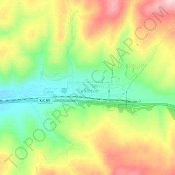
Name: Culdesac topographic map, elevation, terrain.
Location: Culdesac, Nez Perce County, Idaho, United States (46.37151 -116.68299 46.37856 -116.66015)
Average elevation: 588 m
Minimum elevation: 469 m
Maximum elevation: 722 m
Make a donation
Gear up for your next adventure:
As an Amazon Associate, this site earns from qualifying purchases at no extra cost to you.
Other topographic maps
Click on a map to view its topography, its elevation and its terrain.