
Bischofrode topographic map
Interactive map
Click on the map to display elevation.
About this map
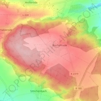
Name: Bischofrode topographic map, elevation, terrain.
Average elevation: 244 m
Minimum elevation: 148 m
Maximum elevation: 300 m
Other topographic maps
Click on a map to view its topography, its elevation and its terrain.
Wolferode
Deutschland > Sachsen-Anhalt > Mansfeld-Südharz > Lutherstadt Eisleben > Wolferode
Wolferode, Lutherstadt Eisleben, Mansfeld-Südharz, Sachsen-Anhalt, 06295, Deutschland
Average elevation: 230 m