Geolocate

Hurlbut topographic map

Click on the map to display elevation.

About this map

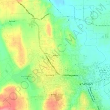
Name: Hurlbut topographic map, elevation, terrain.

Location: Hurlbut, Sonoma County, California, 95472, United States (38.39260 -122.85845 38.43260 -122.81845)

Average elevation: 43 m

Minimum elevation: 7 m

Maximum elevation: 96 m

Gear up for your next adventure:

🧼Biodegradable Camp Soap - Environmentally friendly cleaning for gear and body
🧰Multitool Knife - Compact and versatile tool for outdoor use
🕯️Camping Lantern - Illuminates your entire campsite with high-efficiency LEDs
🥾Hiking Shoes - Durable and comfortable shoes for trail hiking
🥾Light Trekking Boots - Supportive boots for multi-day treks

As an Amazon Associate, this site earns from qualifying purchases at no extra cost to you.