
Make a donation
Gear up for your next adventure:
As an Amazon Associate, this site earns from qualifying purchases at no extra cost to you.
Megalopoli topographic map
Click on the map to display elevation.
Make a donation
Gear up for your next adventure:
As an Amazon Associate, this site earns from qualifying purchases at no extra cost to you.
Megalopoli
Megalopoli is situated in a wide valley, surrounded by mountains: the Taygetus to the south, the Mainalo to the north, the Tsemperou to the southeast and the Lykaion to the west. Its elevation is 430 m above sea level. The river Alfeios flows through this valley, coming from the east and flowing to the north, passing south and west of the town. Its tributary Elissonas passes north of the town. The large lignite deposits around Megalopoli are being exploited by open-pit mining. The Megalopoli Power Plant, 3 km northwest of the town centre, has produced electricity from this lignite since 1969.
Make a donation
Gear up for your next adventure:
As an Amazon Associate, this site earns from qualifying purchases at no extra cost to you.
About this map
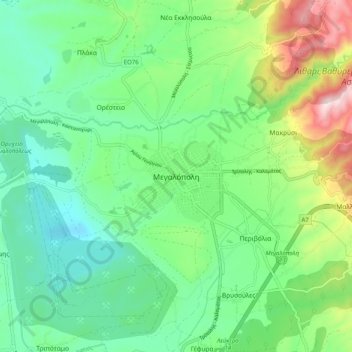
Name: Megalopoli topographic map, elevation, terrain.
Average elevation: 434 m
Minimum elevation: 279 m
Maximum elevation: 811 m
Make a donation
Gear up for your next adventure:
As an Amazon Associate, this site earns from qualifying purchases at no extra cost to you.