
Make a donation
Gear up for your next adventure:
As an Amazon Associate, this site earns from qualifying purchases at no extra cost to you.
Bendestorf topographic map
Click on the map to display elevation.
Make a donation
Gear up for your next adventure:
As an Amazon Associate, this site earns from qualifying purchases at no extra cost to you.
About this map
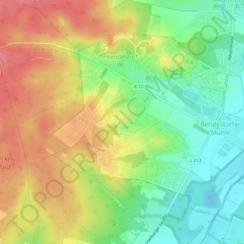
Name: Bendestorf topographic map, elevation, terrain.
Average elevation: 48 m
Minimum elevation: 14 m
Maximum elevation: 92 m
Make a donation
Gear up for your next adventure:
As an Amazon Associate, this site earns from qualifying purchases at no extra cost to you.
Other topographic maps
Click on a map to view its topography, its elevation and its terrain.
Make a donation
Gear up for your next adventure:
As an Amazon Associate, this site earns from qualifying purchases at no extra cost to you.
Holm-Seppensen
Deutschland > Niedersachsen > Landkreis Harburg > Buchholz in der Nordheide
Average elevation: 61 m
Langenrehm
Deutschland > Niedersachsen > Landkreis Harburg
Langenrehm liegt in den Südausläufern der Harburger Berge. Der östlich vom Ortskern gelegene Gannaberg ist mit etwa 155 m Höhe neben dem gleich hohen Hülsenberg, der sich etwas weiter nördlich von diesem befindet, die höchste Erhebung dieser zum Naturraum Schwarze Berge gehörenden Landschaft.
Average elevation: 115 m
Make a donation
Gear up for your next adventure:
As an Amazon Associate, this site earns from qualifying purchases at no extra cost to you.
Make a donation
Gear up for your next adventure:
As an Amazon Associate, this site earns from qualifying purchases at no extra cost to you.