
Thank you for supporting this site ❤️
Make a donation
Make a donation
Gear up for your next adventure:
As an Amazon Associate, this site earns from qualifying purchases at no extra cost to you.
Tordesillas topographic map
Click on the map to display elevation.
Thank you for supporting this site ❤️
Make a donation
Make a donation
Gear up for your next adventure:
As an Amazon Associate, this site earns from qualifying purchases at no extra cost to you.
About this map
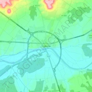
Name: Tordesillas topographic map, elevation, terrain.
Location: Tordesillas, Valladolid, Castille-et-León, 47100, Espagne (41.46085 -5.04053 41.54085 -4.96053)
Average elevation: 695 m
Minimum elevation: 660 m
Maximum elevation: 835 m
Thank you for supporting this site ❤️
Make a donation
Make a donation
Gear up for your next adventure:
As an Amazon Associate, this site earns from qualifying purchases at no extra cost to you.