Geolocate

Kidangoor topographic map

Click on the map to display elevation.

About this map

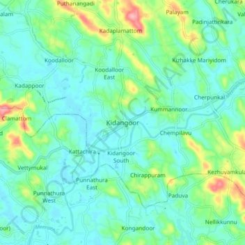
Name: Kidangoor topographic map, elevation, terrain.

Location: Kidangoor, Meenachil, Kottayam, Kerala, 686752, India (9.64461 76.57037 9.72461 76.65037)

Average elevation: 29 m

Minimum elevation: 1 m

Maximum elevation: 119 m

Other topographic maps

Click on a map to view its topography, its elevation and its terrain.

Melukavu

India > Kerala > Meenachil > Melukavumattom

Average elevation: 599 m

Poonjar-Thekkekara

India > Kerala > Meenachil > Vazhikadavu

Average elevation: 376 m

Chovoor

India > Kerala > Meenachil

Average elevation: 327 m

Gear up for your next adventure:

💧Collapsible Water Bottle - Space-saving water bottle for outdoor activities
🧦Crew Hiking Socks - Comfortable socks for long-distance hikes
🥾Waterproof Hiking Boots - Boots keeping your feet dry in wet conditions
👖Convertible Hiking Pants - Zip-off legs to adapt to changing weather conditions
🥾Mountain Hiking Shoes - Shoes with superior grip for mountainous terrain

As an Amazon Associate, this site earns from qualifying purchases at no extra cost to you.