Geolocate

Taian topographic map

Click on the map to display elevation.

About this map

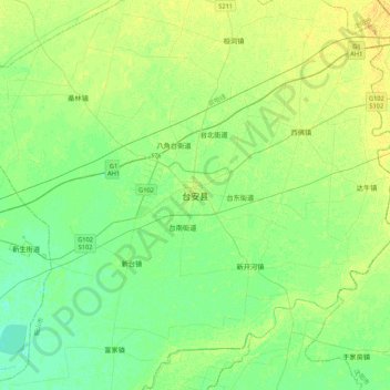
Name: Taian topographic map, elevation, terrain.

Location: Taian, Tai'an County, Anshan City, Liaoning, China (41.21855 122.26683 41.53855 122.58683)

Average elevation: 10 m

Minimum elevation: 2 m

Maximum elevation: 19 m

Gear up for your next adventure:

🏃Hydration Running Vest - Carry water and maps close to your body for speed
🔪Outdoor Multitool - Versatile tool for repairs and food prep in the wild
🦯Trekking Poles - Reduced impact on joints for steep topographic climbs
🧤Insulated Winter Gloves - Heavy-duty protection for sub-zero Canadian adventures
🍽️Titanium Camping Spork - Ultralight and indestructible eating utensil

As an Amazon Associate, this site earns from qualifying purchases at no extra cost to you.