
Make a donation
Gear up for your next adventure:
As an Amazon Associate, this site earns from qualifying purchases at no extra cost to you.
Jarosław County topographic map
Click on the map to display elevation.
Make a donation
Gear up for your next adventure:
As an Amazon Associate, this site earns from qualifying purchases at no extra cost to you.
About this map
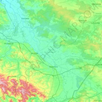
Name: Jarosław County topographic map, elevation, terrain.
Location: Jarosław County, Subcarpathian Voivodeship, Poland (49.83732 22.41048 50.21290 23.15428)
Average elevation: 216 m
Minimum elevation: 166 m
Maximum elevation: 430 m
Make a donation
Gear up for your next adventure:
As an Amazon Associate, this site earns from qualifying purchases at no extra cost to you.
Other topographic maps
Click on a map to view its topography, its elevation and its terrain.
Bieszczady
Poland > Subcarpathian Voivodeship > Bieszczady County > Zatwarnica
Average elevation: 928 m
Górny Koniec
Poland > Subcarpathian Voivodeship > Dębica County > Stara Jastrząbka
Average elevation: 240 m
Make a donation
Gear up for your next adventure:
As an Amazon Associate, this site earns from qualifying purchases at no extra cost to you.
Grzybowa Góra
Poland > Subcarpathian Voivodeship > Stalowa Wola County > Jastkowice
Average elevation: 174 m
Błonie Rzeźnicze
Poland > Subcarpathian Voivodeship > Przeworsk County > Przeworsk
Average elevation: 198 m
Make a donation
Gear up for your next adventure:
As an Amazon Associate, this site earns from qualifying purchases at no extra cost to you.
Haliga
Poland > Subcarpathian Voivodeship > Przemyśl County > Przedmieście Dubieckie
Average elevation: 271 m
Mokłuczka
Poland > Subcarpathian Voivodeship > Rzeszów County > Błażowa Dolna
Average elevation: 320 m
Make a donation
Gear up for your next adventure:
As an Amazon Associate, this site earns from qualifying purchases at no extra cost to you.
Stalowa Wola
Poland > Subcarpathian Voivodeship > Stalowa Wola County > Stalowa Wola
Average elevation: 158 m
Make a donation
Gear up for your next adventure:
As an Amazon Associate, this site earns from qualifying purchases at no extra cost to you.