
Make a donation
Gear up for your next adventure:
As an Amazon Associate, this site earns from qualifying purchases at no extra cost to you.
South Roxana topographic map
Click on the map to display elevation.
Make a donation
Gear up for your next adventure:
As an Amazon Associate, this site earns from qualifying purchases at no extra cost to you.
About this map
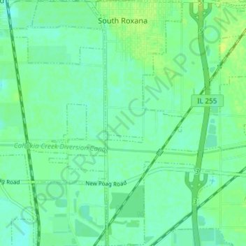
Name: South Roxana topographic map, elevation, terrain.
Location: South Roxana, Madison County, Illinois, 62087, United States (38.78607 -90.08109 38.83333 -90.04822)
Average elevation: 130 m
Minimum elevation: 123 m
Maximum elevation: 143 m
Make a donation
Gear up for your next adventure:
As an Amazon Associate, this site earns from qualifying purchases at no extra cost to you.
Other topographic maps
Click on a map to view its topography, its elevation and its terrain.
Make a donation
Gear up for your next adventure:
As an Amazon Associate, this site earns from qualifying purchases at no extra cost to you.
Wood River
United States > Illinois > Madison County > Wood River > Wood River
Average elevation: 138 m
Glen Carbon
United States > Illinois > Madison County > Glen Carbon > Glen Carbon
Average elevation: 158 m
Collinsville
United States > Illinois > Madison County > Collinsville > Collinsville
Average elevation: 159 m
Make a donation
Gear up for your next adventure:
As an Amazon Associate, this site earns from qualifying purchases at no extra cost to you.