Geolocate

Petaluma topographic map

Click on the map to display elevation.

About this map

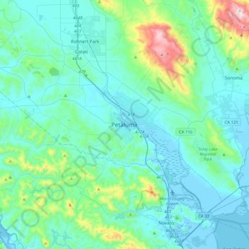
Name: Petaluma topographic map, elevation, terrain.

Location: Petaluma, Sonoma County, California, 94952, United States (38.07258 -122.79647 38.39258 -122.47647)

Average elevation: 117 m

Minimum elevation: -5 m

Maximum elevation: 809 m

Gear up for your next adventure:

🧥Insulated Jacket - Keep warm in cold outdoor conditions
💡Solar Camping Lamp - Eco-friendly lighting for campsites
Lightweight Backpacking Tent - Compact tent for efficient hiking trips
🚲MTB Frame Bag - Carry tools and maps directly on your bicycle frame
🚑Survival Whistle - Signal for help across long distances in mountains

As an Amazon Associate, this site earns from qualifying purchases at no extra cost to you.