Geolocate

Santiago topographic map

Click on the map to display elevation.

About this map

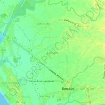
Name: Santiago topographic map, elevation, terrain.

Location: Santiago, Zambales, Central Luzon, 2202, Philippines (15.28282 119.99869 15.32282 120.03869)

Average elevation: 11 m

Minimum elevation: 0 m

Maximum elevation: 21 m

Gear up for your next adventure:

🔥Camping Stove - Portable stoves to cook outdoors with ease
🥾Trail Running Shoes - Lightweight and durable shoes for trail running
🔦LED Flashlight - Powerful and long-lasting flashlight for camping and emergencies
🛏️Camping Sleeping Mat - Comfortable mats for sleeping outdoors
🧦Hiking Liner Socks - Thin base layer to prevent friction and blisters

As an Amazon Associate, this site earns from qualifying purchases at no extra cost to you.