
Make a donation
Gear up for your next adventure:
As an Amazon Associate, this site earns from qualifying purchases at no extra cost to you.
Saint-André-Treize-Voies topographic map
Click on the map to display elevation.
Make a donation
Gear up for your next adventure:
As an Amazon Associate, this site earns from qualifying purchases at no extra cost to you.
Saint-André-Treize-Voies
Le territoire municipal de Saint-André-Treize-Voies s’étend sur 1 895 hectares. L’altitude moyenne de la commune est de 54 mètres, avec des niveaux fluctuant entre 33 et 69 mètres.
Make a donation
Gear up for your next adventure:
As an Amazon Associate, this site earns from qualifying purchases at no extra cost to you.
About this map
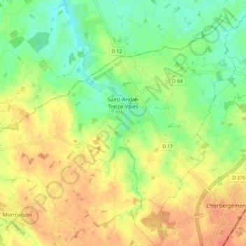
Name: Saint-André-Treize-Voies topographic map, elevation, terrain.
Average elevation: 53 m
Minimum elevation: 31 m
Maximum elevation: 72 m
Make a donation
Gear up for your next adventure:
As an Amazon Associate, this site earns from qualifying purchases at no extra cost to you.
Other topographic maps
Click on a map to view its topography, its elevation and its terrain.
Château de la Chabotterie
France > Pays de la Loire > Vendée > Montréverd > Saint-Sulpice-le-Verdon
Average elevation: 68 m
La Petite Roussière
France > Pays de la Loire > Vendée > Montréverd > Mormaison
Average elevation: 57 m
Make a donation
Gear up for your next adventure:
As an Amazon Associate, this site earns from qualifying purchases at no extra cost to you.
La Siffraire
France > Pays de la Loire > Vendée > Montréverd > Saint-Sulpice-le-Verdon > La Siffraire
Average elevation: 65 m