
Thank you for supporting this site ❤️
Make a donation
Make a donation
Gear up for your next adventure:
As an Amazon Associate, this site earns from qualifying purchases at no extra cost to you.
Sarreaus topographic map
Click on the map to display elevation.
Thank you for supporting this site ❤️
Make a donation
Make a donation
Gear up for your next adventure:
As an Amazon Associate, this site earns from qualifying purchases at no extra cost to you.
Sarreaus
Sarreaus liegt ca. 36 Kilometer südsüdöstlich der Provinzhauptstadt Ourense in einer durchschnittlichen Höhe von ca. 645 m.
Thank you for supporting this site ❤️
Make a donation
Make a donation
Gear up for your next adventure:
As an Amazon Associate, this site earns from qualifying purchases at no extra cost to you.
About this map
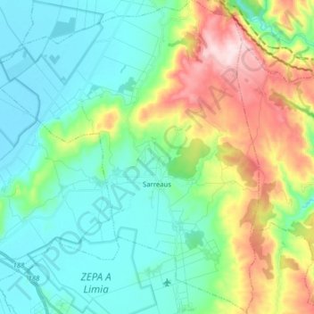
Name: Sarreaus topographic map, elevation, terrain.
Location: Sarreaus, A Limia, Ourense, Galicien, 32631, Spanien (42.04029 -7.68475 42.15602 -7.55309)
Average elevation: 718 m
Minimum elevation: 614 m
Maximum elevation: 988 m
Thank you for supporting this site ❤️
Make a donation
Make a donation
Gear up for your next adventure:
As an Amazon Associate, this site earns from qualifying purchases at no extra cost to you.