
Hope Island topographic map
Click on the map to display elevation.
About this map
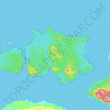
Name: Hope Island topographic map, elevation, terrain.
Average elevation: 16 m
Minimum elevation: -1 m
Maximum elevation: 227 m
Other topographic maps
Click on a map to view its topography, its elevation and its terrain.
Holberg
Canada > British Columbia > Regional District of Mount Waddington > Area B (Quatsino Sound/Cape Scott) > Holberg
Average elevation: 150 m
Schloss Island
Canada > British Columbia > Regional District of Mount Waddington > Area B (Quatsino Sound/Cape Scott)
Average elevation: 21 m
William Lake
Canada > British Columbia > Regional District of Mount Waddington > Area B (Quatsino Sound/Cape Scott)
Average elevation: 158 m
Mount Lemon
Canada > British Columbia > Regional District of Mount Waddington > Area B (Quatsino Sound/Cape Scott)
Average elevation: 124 m