Geolocate

Huonville topographic map

Click on the map to display elevation.

About this map

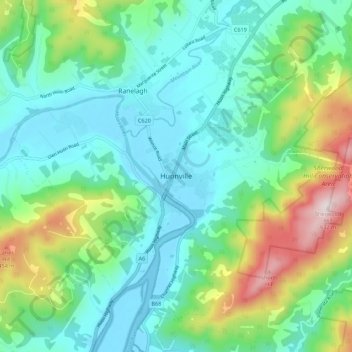
Name: Huonville topographic map, elevation, terrain.

Location: Huonville, Tasmania, Australia (-43.06924 147.01028 -42.98924 147.09028)

Average elevation: 162 m

Minimum elevation: -3 m

Maximum elevation: 629 m

Gear up for your next adventure:

Bushcraft Tarp - Versatile emergency shelter or gear protection
🥾Trail Hiking Boots - Supportive boots for rough trails
🧴First Aid Kit - Essential first aid supplies for outdoor emergencies
🥽Outdoor Goggles - Protective eyewear for outdoor activities
🥫Freeze-Dried Meals - Lightweight, high-calorie nutrition for multi-day treks

As an Amazon Associate, this site earns from qualifying purchases at no extra cost to you.