
Make a donation
Gear up for your next adventure:
As an Amazon Associate, this site earns from qualifying purchases at no extra cost to you.
Trousdale topographic map
Click on the map to display elevation.
Make a donation
Gear up for your next adventure:
As an Amazon Associate, this site earns from qualifying purchases at no extra cost to you.
About this map
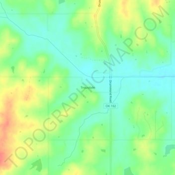
Name: Trousdale topographic map, elevation, terrain.
Location: Trousdale, Pottawatomie County, Oklahoma, United States (35.02119 -97.06280 35.06119 -97.02280)
Average elevation: 304 m
Minimum elevation: 281 m
Maximum elevation: 339 m
Make a donation
Gear up for your next adventure:
As an Amazon Associate, this site earns from qualifying purchases at no extra cost to you.
Other topographic maps
Click on a map to view its topography, its elevation and its terrain.
Make a donation
Gear up for your next adventure:
As an Amazon Associate, this site earns from qualifying purchases at no extra cost to you.
Make a donation
Gear up for your next adventure:
As an Amazon Associate, this site earns from qualifying purchases at no extra cost to you.
Pink
United States > Oklahoma > Pottawatomie County
The 1891 Oklahoma and Indian Territories map portrays Shawneetown (Shawnee) as the only settlement north of Little River in the future Pottawatomie County. Pink appears later on Cram's 1898 Oklahoma and Indian Territory Map.] Topographic mapping of Pink and Pottawatomie County began sometime after 1903. Pink…
Average elevation: 324 m