
Kastel topographic map
Interactive map
Click on the map to display elevation.
About this map
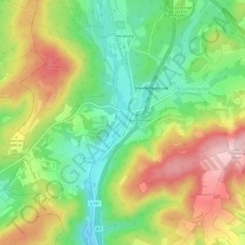
Name: Kastel topographic map, elevation, terrain.
Average elevation: 440 m
Minimum elevation: 327 m
Maximum elevation: 585 m
Other topographic maps
Click on a map to view its topography, its elevation and its terrain.
Primstal
Deutschland > Saarland > Landkreis St. Wendel > Nonnweiler
Primstal, Nonnweiler, Landkreis St. Wendel, Saarland, Deutschland
Average elevation: 401 m
Sitzerath
Deutschland > Saarland > Landkreis St. Wendel > Nonnweiler
Sitzerath, Nonnweiler, Landkreis St. Wendel, Saarland, Deutschland
Average elevation: 475 m