Geolocate

Lippincott topographic map

Click on the map to display elevation.

About this map

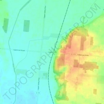
Name: Lippincott topographic map, elevation, terrain.

Location: Lippincott, Champaign County, Ohio, United States (40.17367 -83.79549 40.21367 -83.75549)

Average elevation: 328 m

Minimum elevation: 312 m

Maximum elevation: 358 m

Other topographic maps

Click on a map to view its topography, its elevation and its terrain.

North Lewisburg

United States > Ohio > Champaign County

Average elevation: 335 m

Woodstock

United States > Ohio > Champaign County

Average elevation: 320 m

Mutual

United States > Ohio > Champaign County

Average elevation: 367 m

Mechanicsburg

United States > Ohio > Champaign County

Average elevation: 332 m

Mad River

United States > Ohio > Champaign County > West Liberty

Average elevation: 337 m

St. Paris

United States > Ohio > Champaign County

Average elevation: 373 m

Christiansburg

United States > Ohio > Champaign County

Average elevation: 342 m

Gear up for your next adventure:

🛁Quick-Dry Microfiber Towel - Space-saving towel that dries rapidly on the move
🛏️Camping Sleeping Mat - Comfortable mats for sleeping outdoors
🥾Mountain Trail Shoes - High-traction shoes for mountain trails
🥘Camping Cookware Set - Compact nesting pots and pans for trail cooking
🛌Insulated Sleeping Pad - Critical thermal barrier between you and the cold ground

As an Amazon Associate, this site earns from qualifying purchases at no extra cost to you.