Geolocate

Gangotri topographic map

Click on the map to display elevation.

About this map

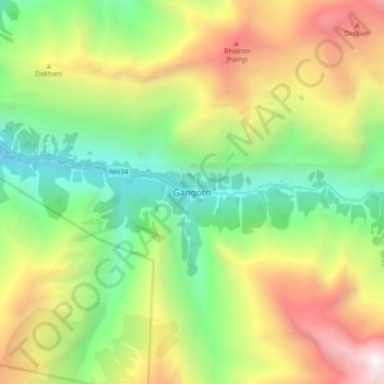
Name: Gangotri topographic map, elevation, terrain.

Location: Gangotri, Bhatwari, Uttarkashi, Uttarakhand, India (30.95437 78.89987 31.03437 78.97987)

Average elevation: 4,139 m

Minimum elevation: 2,864 m

Maximum elevation: 6,029 m

Other topographic maps

Click on a map to view its topography, its elevation and its terrain.

Kedar Tal

India > Uttarakhand > Bhatwari

Average elevation: 4,814 m

Kedar Tal

India > Uttarakhand > Bhatwari

Average elevation: 4,814 m

Gangotri Glacier

India > Uttarakhand > Bhatwari

Average elevation: 5,259 m

Pari Maatri Taal

India > Uttarakhand > Bhatwari

Average elevation: 4,443 m

Harsil

India > Uttarakhand > Bhatwari

Average elevation: 2,761 m

Kalindi Khal Area

India > Uttarakhand > Bhatwari

Average elevation: 5,857 m

Kyarkoti Lake

India > Uttarakhand > Bhatwari

Average elevation: 4,043 m

Gangotri Glacier

India > Uttarakhand > Bhatwari

Average elevation: 5,259 m

Harsil

India > Uttarakhand > Bhatwari

Average elevation: 2,761 m

Gear up for your next adventure:

🥾Trail Hiking Boots - Supportive boots for rough trails
🧤Thermal Hiking Gloves - Grip-enhanced gloves for cold-weather altitude trekking
🧭Orienteering Kit - Tools for map reading and navigation in the wild
🦯Trekking Poles - Reduced impact on joints for steep topographic climbs
🕶️Polarized Sunglasses - Reduces glare from snow and water at high elevations

As an Amazon Associate, this site earns from qualifying purchases at no extra cost to you.