
Make a donation
Gear up for your next adventure:
As an Amazon Associate, this site earns from qualifying purchases at no extra cost to you.
Cirueña topographic map
Click on the map to display elevation.
Make a donation
Gear up for your next adventure:
As an Amazon Associate, this site earns from qualifying purchases at no extra cost to you.
Cirueña
Der Ort Cirueña liegt etwa 44 km (Fahrtstrecke) westlich der Provinzhauptstadt Logroño in einer Höhe von ca. 740 m. Die Stadt Santo Domingo de la Calzada ist nur knapp 7 km in nordwestlicher Richtung entfernt. Das Klima ist gemäßigt bis warm; Regen (ca. 625 mm/Jahr) fällt übers Jahr verteilt.
Make a donation
Gear up for your next adventure:
As an Amazon Associate, this site earns from qualifying purchases at no extra cost to you.
About this map
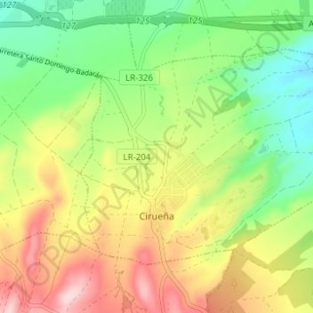
Name: Cirueña topographic map, elevation, terrain.
Location: Cirueña, La Rioja, 26258, Spanien (42.40462 -2.91061 42.43607 -2.84883)
Average elevation: 706 m
Minimum elevation: 597 m
Maximum elevation: 850 m
Make a donation
Gear up for your next adventure:
As an Amazon Associate, this site earns from qualifying purchases at no extra cost to you.
Other topographic maps
Click on a map to view its topography, its elevation and its terrain.