
Make a donation
Gear up for your next adventure:
As an Amazon Associate, this site earns from qualifying purchases at no extra cost to you.
Luzillé topographic map
Click on the map to display elevation.
Make a donation
Gear up for your next adventure:
As an Amazon Associate, this site earns from qualifying purchases at no extra cost to you.
Luzillé
Les plus hautes altitudes de la commune se rencontrent sur le plateau, à l'est, avec 132 m en limite d'Épeigné-les-Bois, alors que la vallée du Beugnon descend jusqu'à 68 m ; elle est fortement encaissée par rapport à l'altitude moyenne du plateau qui va de 100 à 110 m.
Make a donation
Gear up for your next adventure:
As an Amazon Associate, this site earns from qualifying purchases at no extra cost to you.
About this map
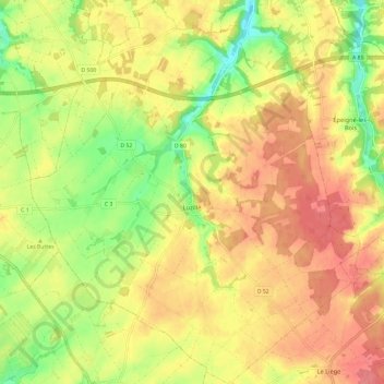
Name: Luzillé topographic map, elevation, terrain.
Average elevation: 106 m
Minimum elevation: 67 m
Maximum elevation: 134 m
Make a donation
Gear up for your next adventure:
As an Amazon Associate, this site earns from qualifying purchases at no extra cost to you.
Other topographic maps
Click on a map to view its topography, its elevation and its terrain.
Le Point du Jour
France > Centre-Val de Loire > Indre-et-Loire > Sainte-Maure-de-Touraine
Average elevation: 100 m
Le Gros Ormeau
France > Centre-Val de Loire > Indre-et-Loire > Cléré-les-Pins
Average elevation: 102 m
Make a donation
Gear up for your next adventure:
As an Amazon Associate, this site earns from qualifying purchases at no extra cost to you.
Les Évées
France > Centre-Val de Loire > Indre-et-Loire > Saint-Martin-le-Beau
Average elevation: 71 m
La Ville
France > Centre-Val de Loire > Indre-et-Loire > Sainte-Maure-de-Touraine
Average elevation: 97 m
Château
France > Centre-Val de Loire > Indre-et-Loire > Sainte-Maure-de-Touraine > La Ville
Average elevation: 92 m
Make a donation
Gear up for your next adventure:
As an Amazon Associate, this site earns from qualifying purchases at no extra cost to you.