Geolocate

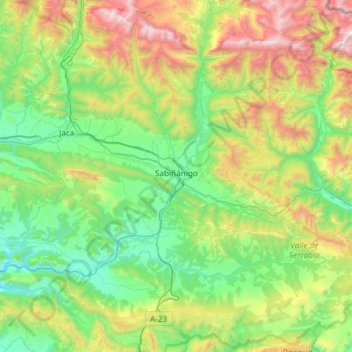
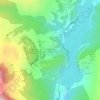
Sabiñánigo topographic map

Click on the map to display elevation.

Sabiñánigo

Sabiñánigo (Samianigo in Aragonese) is a municipality located in the province of Huesca, Aragón, Spain, capital of the comarca of Alto Gállego. Formerly, the region was called Serrablo, hence the demonym "serrablese". Sabiñánigo is at an altitude of 780 m and lies 52 km from Huesca.

Wikipedia (CC-BY-SA 3.0)

About this map

Name: Sabiñánigo topographic map, elevation, terrain.

Location: Sabiñánigo, Alto Gállego, Huesca, Aragon, Spain (42.29555 -0.50628 42.73238 -0.06586)

Average elevation: 1,211 m

Minimum elevation: 573 m

Maximum elevation: 2,869 m

Other topographic maps

Click on a map to view its topography, its elevation and its terrain.
Pico Anayet

Spain > Aragon > Alto Gállego > Sallent de Gállego

Average elevation: 2,176 m

Valle de Tena

Spain > Aragon > Alto Gállego > Búbal

Average elevation: 1,313 m

Lárrede

Spain > Aragon > Alto Gállego > Sabiñánigo

Average elevation: 957 m

Piedrafita de Jaca

Spain > Aragon > Alto Gállego

Average elevation: 1,321 m

Gear up for your next adventure:

🔋Lithium AA Batteries - Long-lasting power that performs in extreme cold
⛺Camping Tent - Weather-resistant tents suitable for 2 to 6 people
🥾Approach Boots - Comfortable boots for hiking and climbing approaches
🥾Light Hiking Boots - Lightweight and comfortable boots for day hikes
🗺️Topographic Maps - Detailed maps to explore trails, mountains, and wilderness areas

As an Amazon Associate, this site earns from qualifying purchases at no extra cost to you.