Geolocate

Moraña topographic map

Click on the map to display elevation.

About this map
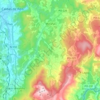
Name: Moraña topographic map, elevation, terrain.

Location: Moraña, Caldas, Pontevedra, Galicia, España (42.51262 -8.62168 42.61282 -8.54120)

Average elevation: 227 m

Minimum elevation: 17 m

Maximum elevation: 586 m

Other topographic maps

Click on a map to view its topography, its elevation and its terrain.

Vilar de Mato

España > Galicia > Caldas > Cuntis

Average elevation: 411 m

Fervenza de Segade

España > Galicia > Caldas > Caldas de Reis

Average elevation: 137 m

Vilameán

España > Galicia > Caldas > Cuntis

Average elevation: 225 m

Marán

España > Galicia > Caldas > Caldas de Reis

Average elevation: 93 m

Mesego

España > Galicia > Caldas > Cuntis

Average elevation: 405 m

Arcos da Condesa

España > Galicia > Caldas > Caldas de Reis

Average elevation: 103 m

Zo

España > Galicia > Caldas > Cuntis

Average elevation: 437 m

Paraimas

España > Galicia > Caldas

Average elevation: 84 m

Os Barreiros

España > Galicia > Caldas > Caldas de Reis

Average elevation: 86 m

Gear up for your next adventure:

🧶550 Survival Paracord - Versatile utility cord for emergency repairs and rigging
🥾Mountain Hiking Boots - High-traction boots for rocky terrain
🧭GPS Handheld Device - Reliable GPS navigation for outdoor adventures
🧭GPS Tracker - Track your location in remote areas safely
🧥Waterproof Hiking Jacket - Protect yourself from rain and wind while hiking

As an Amazon Associate, this site earns from qualifying purchases at no extra cost to you.