Geolocate

Fematre topographic map

Click on the map to display elevation.

About this map

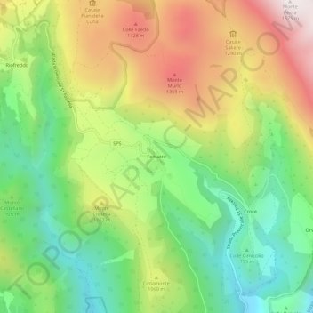
Name: Fematre topographic map, elevation, terrain.

Location: Fematre, Visso, Macerata, Marche, Italy (42.91158 12.99376 42.95158 13.03376)

Average elevation: 966 m

Minimum elevation: 519 m

Maximum elevation: 1,569 m

Gear up for your next adventure:

🐕Hiking Dog Pack - Let your canine companion carry their own water and food
🧳Compression Sacks - Maximize space in your backpack by shrinking gear
🔋Solar Power Bank - Keep your GPS and devices charged during long outdoor trips
Camping Coffee Maker - Brew fresh coffee anywhere on the topographic map
🎒Backpack Rain Cover - External shield to keep your entire pack dry

As an Amazon Associate, this site earns from qualifying purchases at no extra cost to you.