Geolocate

Kavungal topographic map

Click on the map to display elevation.

About this map

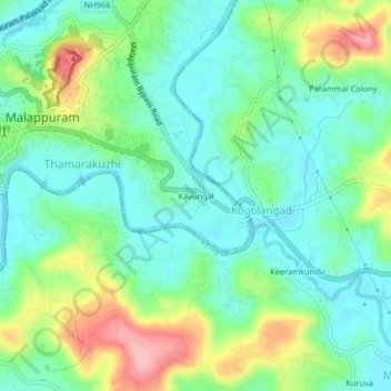
Name: Kavungal topographic map, elevation, terrain.

Location: Kavungal, Malappuram, Ernad, Malappuram, Kerala, 676500, India (11.01481 76.07682 11.05481 76.11682)

Average elevation: 54 m

Minimum elevation: 11 m

Maximum elevation: 149 m

Other topographic maps

Click on a map to view its topography, its elevation and its terrain.

Alathurpadi

India > Kerala > Ernad > Malappuram

Average elevation: 64 m

Irumbuzhi

India > Kerala > Ernad > Malappuram

Average elevation: 43 m

Malappuram

India > Kerala > Ernad > Malappuram

Average elevation: 62 m

Gear up for your next adventure:

🥾Trail Running Boots - Durable shoes designed for trail running
💧Filtered Water Bottle - Safe drinking water on the go
🧦Outdoor Socks - Durable socks designed for hiking and outdoor sports
🗺️Topographic Maps - Detailed maps to explore trails, mountains, and wilderness areas
🧢Sun Hat - Wide-brim hat for sun protection

As an Amazon Associate, this site earns from qualifying purchases at no extra cost to you.