Geolocate

Kalikiri topographic map

Click on the map to display elevation.

About this map

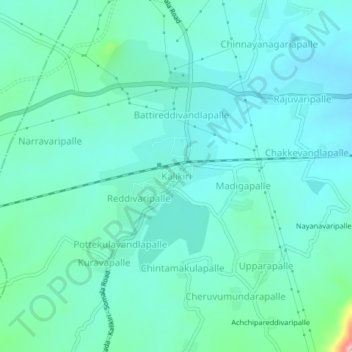
Name: Kalikiri topographic map, elevation, terrain.

Location: Kalikiri, Annamayya, Andhra Pradesh, 517237, India (13.62264 78.78223 13.66264 78.82223)

Average elevation: 544 m

Minimum elevation: 514 m

Maximum elevation: 690 m

Gear up for your next adventure:

🥾Trekking Poles - Adjustable trekking poles to reduce knee stress and improve stability
Tent Footprint - Protect tent floor and increase durability
Camping Groundsheet - Protect your tent from moisture and dirt
🛏️Sleeping Bag - Warm and compact sleeping bags for outdoor camping
🥾Light Trekking Boots - Supportive boots for multi-day treks

As an Amazon Associate, this site earns from qualifying purchases at no extra cost to you.