
Challes topographic map
Interactive map
Click on the map to display elevation.
About this map
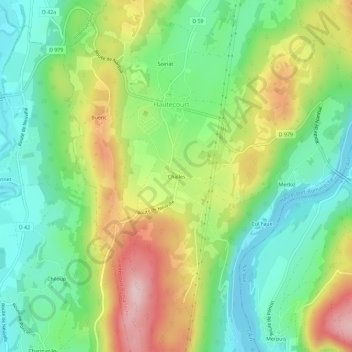
Name: Challes topographic map, elevation, terrain.
Average elevation: 373 m
Minimum elevation: 270 m
Maximum elevation: 539 m
Other topographic maps
Click on a map to view its topography, its elevation and its terrain.
Soiriat
France > Auvergne-Rhône-Alpes > Ain > Hautecourt-Romanèche > Hautecourt
Soiriat, Hautecourt, Hautecourt-Romanèche, Bourg-en-Bresse, Ain, Auvergne-Rhône-Alpes, France métropolitaine, 01250, France
Average elevation: 366 m