
Make a donation
Gear up for your next adventure:
As an Amazon Associate, this site earns from qualifying purchases at no extra cost to you.
Wulveringem topographic map
Click on the map to display elevation.
Make a donation
Gear up for your next adventure:
As an Amazon Associate, this site earns from qualifying purchases at no extra cost to you.
Wulveringem
Wulveringem ligt op de grens van Zandlemig Vlaanderen en, in het noorden, de Oudlandpolders. De hoogte bedraagt ongeveer 10 meter.
Make a donation
Gear up for your next adventure:
As an Amazon Associate, this site earns from qualifying purchases at no extra cost to you.
About this map
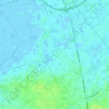
Name: Wulveringem topographic map, elevation, terrain.
Location: Wulveringem, Beauvoorde, Veurne, West-Vlaanderen, 8630, België (51.01380 2.61506 51.04665 2.71592)
Average elevation: 3 m
Minimum elevation: -4 m
Maximum elevation: 12 m
Make a donation
Gear up for your next adventure:
As an Amazon Associate, this site earns from qualifying purchases at no extra cost to you.
Other topographic maps
Click on a map to view its topography, its elevation and its terrain.
Westhoekduinen, duinen van Cabour, De Moeren en plateau van Izenberge
België > West-Vlaanderen > Veurne > Veurne
Average elevation: 1 m
Make a donation
Gear up for your next adventure:
As an Amazon Associate, this site earns from qualifying purchases at no extra cost to you.