Geolocate

Longgang topographic map

Click on the map to display elevation.

About this map

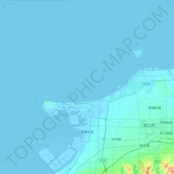
Name: Longgang topographic map, elevation, terrain.

Location: Longgang, Longkou City, Yantai, Shandong, 265700, China (37.55148 119.99360 37.87892 120.38029)

Average elevation: 10 m

Minimum elevation: -4 m

Maximum elevation: 394 m

Gear up for your next adventure:

🏃Hydration Running Vest - Carry water and maps close to your body for speed
🥤Collapsible Travel Cup - Saves space and weight in your mess kit
🧥Softshell Hiking Jacket - The perfect balance of wind protection and breathability
🧴Bear Spray Holster - Quick-access carry for essential Canadian wilderness safety
🧥Packable Rain Jacket - Breathable waterproof layer for unpredictable weather

As an Amazon Associate, this site earns from qualifying purchases at no extra cost to you.