
Thank you for supporting this site ❤️
Make a donation
Make a donation
Gear up for your next adventure:
As an Amazon Associate, this site earns from qualifying purchases at no extra cost to you.
Cuyahuani topographic map
Click on the map to display elevation.
Thank you for supporting this site ❤️
Make a donation
Make a donation
Gear up for your next adventure:
As an Amazon Associate, this site earns from qualifying purchases at no extra cost to you.
About this map
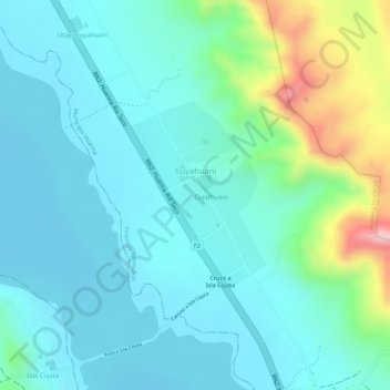
Name: Cuyahuani topographic map, elevation, terrain.
Average elevation: 3,860 m
Minimum elevation: 3,810 m
Maximum elevation: 4,032 m
Thank you for supporting this site ❤️
Make a donation
Make a donation
Gear up for your next adventure:
As an Amazon Associate, this site earns from qualifying purchases at no extra cost to you.
Other topographic maps
Click on a map to view its topography, its elevation and its terrain.
Pairumani (disperso)
Bolivia > La Paz > Provincia Omasuyos > Municipio Huarina > Pairumani (disperso)
Average elevation: 3,976 m